Combine Steps and Tasks
Global datasets of base elevation (land surface elevation and ocean bathymetry) do not typically include the latest datasets around Antarctica needed for ice-sheet and ice-shelf modeling. For this reason, we typically combine a global topography dataset north of the Southern Ocean with one for Antarctica.
The polaris.tasks.e3sm.init.topo.combine.CombineStep step is a key
component of the topography framework. It is responsible for combining global
and Antarctic topography datasets into a single dataset suitable for use in
E3SM simulations. The step supports blending datasets across specified latitude
ranges and remapping them to a target grid.
The
polaris.tasks.e3sm.init.topo.combine.CubedSphereCombineTask
and
polaris.tasks.e3sm.init.topo.combine.LatLonCombineTask
wrap the CombineStep into tasks that can be used to generate and cache
combined topography datasets for reuse in other contexts.
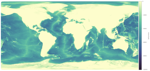
The polaris.tasks.e3sm.init.topo.combine.VizCombinedStep step is
an optional visualization step that can be added to the workflow to create
plots of the combined topography dataset. This step is particularly useful for
debugging or analyzing the combined dataset.
Target Grids and Resolutions
The combine framework is now organized explicitly around the target grid and resolution rather than around a special “low-resolution” mode. Current tasks include:
Cubed-sphere topography on
ne3000Cubed-sphere topography on
ne120Latitude-longitude topography on
1.00000_degreeLatitude-longitude topography on
0.25000_degreeLatitude-longitude topography on
0.12500_degreeLatitude-longitude topography on
0.06250_degreeLatitude-longitude topography on
0.03125_degree
The shared constants and helper functions that define these supported
resolutions now live in polaris.e3sm.init.topo so mesh, ocean, and other
components can use the same resolution logic without importing from the
e3sm/init task family. In particular, use
CUBED_SPHERE_RESOLUTIONS, LAT_LON_RESOLUTIONS,
format_lat_lon_resolution_name(), get_cubed_sphere_resolution(), and
uses_low_res_cubed_sphere() from that framework module.
Latitude-longitude directory names are produced by
format_lat_lon_resolution_name(), which uses
LAT_LON_RESOLUTION_DECIMALS = 5. For example, 0.125 maps to
0.12500_degree and 0.03125 maps to 0.03125_degree.
These resolutions are intended for different downstream uses:
ne3000is the standard high-resolution cubed-sphere product. At roughly 1 km resolution, it is suitable for remapping topography to standard and high-resolution MPAS meshes, approximately 60 km and finer, for scientific applications.ne120is a lower-cost cubed-sphere product at roughly 25 km resolution. It is useful for remapping to coarse meshes such as Icos240 and for regression testing or other non-scientific workflows where the full high-resolution product is not needed.1.00000_degreeis intended for quick, non-scientific testing when a very coarse latitude-longitude product is sufficient.0.25000_degreealigns with the WOA23 (World Ocean Atlas 2023) dataset and can also be used when defining mesh resolution at moderate scales, roughly down to 30 km.0.12500_degree,0.06250_degreeand0.03125_degreeare intended for defining mesh resolution for most scientific runs and will be used by the E3SM v4 unified MPAS mesh across land, river, ocean, and sea-ice.
A series of standalone tasks are available to create each topography dataset on its own:
e3sm/init/topo/combine_bedmap3_gebco2023/cubed_sphere/ne3000/taske3sm/init/topo/combine_bedmap3_gebco2023/cubed_sphere/ne120/taske3sm/init/topo/combine_bedmap3_gebco2023/lat_lon/1.00000_degree/taske3sm/init/topo/combine_bedmap3_gebco2023/lat_lon/0.25000_degree/taske3sm/init/topo/combine_bedmap3_gebco2023/lat_lon/0.12500_degree/taske3sm/init/topo/combine_bedmap3_gebco2023/lat_lon/0.06250_degree/taske3sm/init/topo/combine_bedmap3_gebco2023/lat_lon/0.03125_degree/task
Downstream workflows such as topography remapping to the MPAS mesh,
extrapolation of the WOA23 dataset and defining mesh resolution for unified
E3SM v4 meshes will use shared topo/combine steps referenced by their
grid and resolution.
Key Features
Dataset Support: Supports multiple datasets, including
bedmap3,bedmachinev3, andgebco2023.Grid Types: Handles both lat-lon and cubed-sphere target grids.
Blending: Blends global and Antarctic datasets across a configurable latitude range.
Remapping: Uses tools like
mbtempest,ESMF_RegridWeightGenandncremapfor remapping datasets to the target grid.Output: Produces combined topography datasets with consistent variables and attributes.
Visualization: Generates rasterized images of various fields (e.g., base elevation, ice draft) using the
datashaderlibrary.
Configuration Options
The CombineStep step is configured through the [combine_topo] section in
the configuration file. Key options include:
resolution_latlon: Target resolution for lat-lon grids (in degrees).resolution_cubedsphere: Target resolution for cubed-sphere grids (e.g.,3000for NExxx grids).latminandlatmax: Latitude range for blending datasets.ntasksandmin_tasks: Number of MPI tasks for remapping.method: Remapping method (e.g.,bilinear).lat_tilesandlon_tiles: Number of tiles to split the global dataset for parallel remapping.renorm_thresh: Threshold for renormalizing Antarctic variables during blending.
Workflow
Setup: The step downloads required datasets and sets up input/output files.
Modification: Antarctic and global datasets are modified to include necessary variables and attributes.
Remapping: Datasets are remapped to the target grid using SCRIP files and weight generation.
Blending: The datasets are blended across the specified latitude range.
Output: The combined dataset is saved in NetCDF format.
Optional Field Plotting: Each field in the dataset is rasterized and saved as an image with a colorbar.
Example Usage
Below is an example of how the CombineStep can be added to a Polaris
task:
from polaris.tasks.e3sm.init.topo.combine import CombineStep

component = task.component
subdir = CombineStep.get_subdir()
if subdir in component.steps:
    step = component.steps[subdir]
else:
    step = CombineStep(component=component, subdir=subdir)
    component.add_step(step)
task.add_step(step)
To create a cubed-sphere combine task for caching combined datasets:
from polaris.tasks.e3sm.init.topo.combine import CubedSphereCombineTask

combine_task = CubedSphereCombineTask(component=my_component, resolution=3000)
my_component.add_task(combine_task)
To create a latitude-longitude combine task:
from polaris.tasks.e3sm.init.topo.combine import LatLonCombineTask

combine_task = LatLonCombineTask(component=my_component, resolution=0.25)
my_component.add_task(combine_task)
Below is an example of how the VizCombinedStep can be added to a Polaris task:
from polaris.tasks.e3sm.init.topo.combine import VizCombinedStep

viz_step = VizCombinedStep(component=my_component, combine_step=combine_step)
my_component.add_step(viz_step)
Since there is a single shared step for each pair of Antarctic and global
datasets, the step should be added only once to the component and the existing
step (identifiable via its subdir) should be used subsequently.
The VizCombinedStep is typically added only when visualization is explicitly required, as it is not part of the default workflow.
For more details, refer to the source code of the
polaris.tasks.e3sm.init.topo.combine.CombineStep and
polaris.tasks.e3sm.init.topo.combine.CubedSphereCombineTask and
polaris.tasks.e3sm.init.topo.combine.LatLonCombineTask classes.
Note
Since CombineStep is expensive and time-consuming to run, it sets
self.default_cached = True in its __init__. Downstream tasks that add
a CombineStep will therefore automatically use cached outputs without
needing to opt in via the suite file or --cached flag.
The standalone
polaris.tasks.e3sm.init.topo.combine.task.CubedSphereCombineTask
and
polaris.tasks.e3sm.init.topo.combine.task.LatLonCombineTask
tasks exist specifically to regenerate these products, so they add all of
their steps to self.free_running_steps, overriding the default_cached
default and ensuring the steps always run.
See Automatic cache use with default_cached and free_running_steps for a full description of the
default_cached / free_running_steps mechanism.