Remapping Topography to MPAS Base Meshes
The e3sm/init component includes a workflow for remapping combined topography
datasets to MPAS base meshes at a range of resolutions. This process ensures
that bathymetry, land-ice thickness, and related fields are accurately mapped
from the cubed-sphere grid onto the unstructured MPAS mesh used in E3SM
simulations.
Remapping Workflow Overview
The remapping workflow is composed of several modular steps, each responsible for a specific part of the process:
Masking: The
polaris.tasks.e3sm.init.topo.remap.MaskTopoStepapplies ocean and land masks to the combined topography dataset on the cubed-sphere grid. This step generates masked versions of all topography fields, as well as fractional land and ocean coverage.Remapping: The
polaris.tasks.e3sm.init.topo.remap.RemapTopoStepremaps the masked topography fields from the cubed-sphere grid to the MPAS mesh. This step can be run with or without smoothing, depending on configuration.Smoothing: Smoothing is optionally applied during remapping. The workflow supports both unsmoothed and smoothed topography, with the smoothed step depending on the unsmoothed results.
Visualization: The
polaris.tasks.e3sm.init.topo.remap.VizRemappedTopoStepcan be added to generate plots of the remapped fields for quality control.
The polaris.tasks.e3sm.init.topo.remap.RemapTopoTask orchestrates these steps for each supported MPAS base mesh.
Step Dependencies
The typical dependency chain is:
CombineStep(combines global and Antarctic topography)MaskTopoStep(applies land/ocean masks)RemapTopoStep(remaps to MPAS mesh, optionally with smoothing)VizRemappedTopoStep(optional visualization)
Configuration Options
The remapping steps are configured through the shared [spherical_mesh]
section and the [remap_topography] section in the configuration file. Key
options include:
antarctic_boundary_convention: Antarctic boundary convention used when masking the combined topography before remapping. Supported values arecalving_front,grounding_line, andbedrock_zero.ntasksandmin_tasks: Number of MPI tasks for remapping.renorm_threshold: Fractional threshold for renormalizing elevation variables.expand_distanceandexpand_factor: Smoothing parameters (set to 0 and 1 for no smoothing).Additional options for visualization colormaps and normalization.
The Antarctic boundary convention controls which below-sea-level Antarctic
cells are treated as ocean before remapping. calving_front excludes all
ice-covered cells from the ocean mask, grounding_line excludes grounded ice
but includes ice shelves, and bedrock_zero treats all below-sea-level
bedrock as ocean.
For the low-resolution version, additional configuration options are provided
in the remap_low_res.cfg file.
Workflow
Masking: The
MaskTopoStepapplies convention-aware land and ocean masks to the combined topography dataset, producing masked fields and fractional coverage variables.Remapping: The
RemapTopoStepremaps the masked topography fields to the MPAS mesh. If smoothing is enabled, both unsmoothed and smoothed steps are created, with the smoothed step depending on the unsmoothed output.Smoothing: Smoothing parameters are controlled via configuration. If no smoothing is requested, the smoothed step simply symlinks the unsmoothed results.
Visualization: The
VizRemappedTopoStepcan be added to plot each remapped field using configuration-driven colormaps and normalization.Output: The final remapped topography is saved as
topography_remapped.ncfor each mesh and smoothing option.
Supported Mesh Types
add_remap_topo_tasks registers tasks for all supported base meshes,
including both simple (quasi-uniform and icosahedral) base meshes and
named unified meshes (see Unified base-mesh tasks). The set
of mesh names is the union of get_base_mesh_step_names() and
UNIFIED_MESH_NAMES.
Example Usage
To get the shared remap steps for a specific mesh:
from polaris.tasks.e3sm.init.topo.remap import get_remap_topo_steps

steps, config = get_remap_topo_steps(
    mesh_name='u.oi30.lr10',
    smoothing=True,
    include_viz=True,
)
To add the full remapping workflow as a task for each supported mesh:
from polaris.tasks.e3sm.init.topo.remap import add_remap_topo_tasks

add_remap_topo_tasks(component)
This will add a RemapTopoTask for each supported base mesh, including all necessary steps (masking, remapping, smoothing, and optional visualization).
Example: Ocean Fraction on Icos480km Mesh
Below is an example of the ocean fraction field (ocean_frac) remapped
to the Icos480km MPAS mesh:
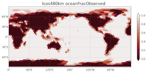
This field indicates the fraction of each MPAS cell that is covered by ocean after remapping, which is important for subsequent steps such as mesh culling and mask generation.
Customization
Remapping options, including smoothing parameters and the number of MPI tasks,
are controlled via the [remap_topography] section in the configuration file.
The workflow supports both unsmoothed and smoothed topography, and can generate
visualizations for each remapped field.
For more details, see the source code for
polaris.tasks.e3sm.init.topo.remap.RemapTopoTask and related steps,
as well as the configuration files remap.cfg and remap_low_res.cfg.
Extending Masking and Smoothing Functionality
Developers may wish to customize how land/ocean masks are generated or how smoothing is applied during remapping. This can be accomplished by subclassing the relevant step classes and overriding their methods:
Customizing Mask Generation
To implement a custom approach for generating land and ocean masks, create a
subclass of polaris.tasks.e3sm.init.topo.remap.MaskTopoStep and
override the define_masks() method. This method receives an xarray.Dataset
and should return two xarray.DataArray objects representing the ocean and land
masks, respectively.
Example:
from polaris.tasks.e3sm.init.topo.remap import MaskTopoStep

class MyCustomMaskStep(MaskTopoStep):
    def define_masks(self, ds):
        # Custom logic for mask generation
        ocean_mask = ...  # compute ocean mask as DataArray
        land_mask = ...   # compute land mask as DataArray
        return ocean_mask, land_mask
You can then use your custom step in place of the default MaskTopoStep when constructing your workflow.
Customizing Smoothing Behavior
To implement custom smoothing logic, subclass
polaris.tasks.e3sm.init.topo.remap.RemapTopoStep and override the
define_smoothing() method. This method receives the unsmoothed topography
dataset and should return the expand_distance and expand_factor (either as
scalars or xarray.DataArray objects) to control the smoothing applied during
remapping.
Example:
from polaris.tasks.e3sm.init.topo.remap import RemapTopoStep

class MyCustomRemapStep(RemapTopoStep):
    def define_smoothing(self, ds_unsmoothed):
        # Custom logic for spatially varying smoothing
        expand_distance = ...  # scalar or DataArray
        expand_factor = ...    # scalar or DataArray
        return expand_distance, expand_factor
This allows for advanced smoothing strategies, such as spatially varying parameters based on mesh properties or scientific requirements.
Integration
To use your custom steps, simply instantiate them in your workflow or override the step creation logic in your task or workflow setup.
For more details, refer to the docstrings and source code of
polaris.tasks.e3sm.init.topo.remap.MaskTopoStep and
polaris.tasks.e3sm.init.topo.remap.RemapTopoStep.